Recreation site (day use only)
Region
Watson Lake
Registration required
No
Total sites
0
Pull through
0
Serviced
to
Gate Open
Gate open year-round
Warning
The dense woods and low visitation make this a popular wildlife corridor. Be bear aware.
Site description
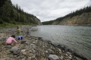
- One-way, 2.2 km forested trail with interpretive panels.
- Trail ends with a view of the canyon at the Liard River.
- The river's Kaska name is Nêt’i Tué’ meaning "river flowing from mountains."
- Parking lot shared with the Town of Watson Lake's Lucky Lake day-use area.
- Gates are closed from 11pm - 7am daily.
Recreation site (day use only)
Location
Highway
Alaska Highway
Highway kilometre
971.0
GPS coordinates
60.019°N 128.580°W
Map download
Liard Canyon Recreation Site Map
(155.64 KB)
Download Map
Site directions
Park at the Lucky Lake day-use area and pass by the baseball diamonds and beach to access the trail.
Services available
Outhouse unisex
Hiking trails
Viewing structures or signage about local cultural and natural history