Recreation site (day use only)
Region
Southern Lakes
Registration required
No
Total sites
0
Pull through
0
Serviced
to
Gate Open
to
Site description
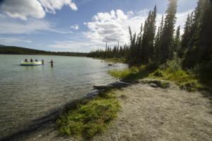
- Small, sandy, unsupervised beach with warm, shallow water and a playground.
- Popular stop for families.
- Its Tagish name Kwáchǫǫ Méne' means "Ling Cod (Burbot) lake."
Recreation site (day use only)
Location
Highway
Klondike Highway
Highway kilometre
152.0
GPS coordinates
60.559°N 134.878°W
Map download
Kookatsoon Lake Recreation Site Map
(182.71 KB)
Download Map
Services available
Outhouse unisex
Bear proof garbage bins
Picnic tables
Playground
At least one wheelchair accessible outhouse
Sandy or cobble beach within short walking distance
Swimming area or dock. No lifeguard