Road accessible campground
Region
Klondike
Registration required
Yes
Total sites
36
Pull through
4
Serviced
to
Gate Open
to
Warning
The trails are also used by wildlife, so make noise and bring bear spray.
Site description
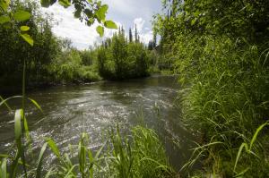
- Has two 1.5 to 2.5 km connected interpretive trail loops. One follows ridge, and the other follows Moose Creek to the Stewart River (Nächo Nyak Gé). The trail goes through open forest to willows on the floodplain. Look for old spruce trees along the ridge.
- The river and creek have popular fishing holes.
- Small ponds mean mosquitoes are common in the summer. They attract birds such as the northern waterthrush, Wilson’s warbler and common yellowthroat.
Campground peak times:
May
June
July
August
September
Location
Highway
Klondike Highway
Highway kilometre
559.0
GPS coordinates
63.509°N 137.026°W
Map download
Moose Creek Campground map
(309.19 KB)
Download Map
Services available
Outhouse unisex
Bear proof garbage bins
Picnic tables
Cook shelter
Fire ring
Bear proof cache
Hiking trails
At least one wheelchair accessible outhouse
At least one wheelchair accessible campsite
Hand pump or water tank provided
Viewing structures or signage about local cultural and natural history
Tent pads or sites available via walking trail
Walk-in sites