Recreation site (day use only)
Region
Kluane
Registration required
No
Total sites
0
Pull through
0
Serviced
to
Gate Open
Gate open year-round
Site description
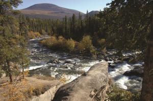
- Rocks below the small waterfall and below the bridge are a good fishing spots on the Aishihik River (Tthe Yänlin).
- The Southern Tutchone name for the falls, Nadèlin, means “water flowing over.”
- Otter Falls appeared on the 1954 Canadian five dollar bill.
- The recreation site overlooks Canyon Lake (Ädäts'ür Män).
- Gates are closed from 11pm - 7am daily.
Recreation site (day use only)
Location
Highway
Alaska Highway
Highway kilometre
1546.0
Secondary road
Aishihik Lake Road
Secondary road kilometre
28.0
GPS coordinates
61.082°N 136.996°W
Map download
Otter Falls Recreation Site Map
(326.21 KB)
Download Map
Site directions
You can reach the falls from a pull-off 100 metres south of the recreation site.
Services available
Outhouse unisex
Bear proof garbage bins
Picnic tables
Cook shelter
Fire ring
Boat launch
Hiking trails
Sandy or cobble beach within short walking distance
Viewing structures or signage about local cultural and natural history