Recreation site (day use only)
Region
Watson Lake
Registration required
No
Total sites
0
Pull through
0
Serviced
to
Gate Open
Gate open year-round
Site description
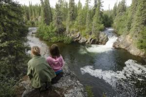
- Has a 0.5 kilometre 1-way boardwalk with interpretive panels. Ends at the waterfall.
- Look for the small black American dippers that feed among the rapids year round and least chipmunks along the trail.
- Look for signs of woodland caribou in winter.
- Gates are closed from 11pm - 7am daily.
Recreation site (day use only)
Location
Highway
Alaska Highway
Highway kilometre
1112.0
Secondary road kilometre
0.0
GPS coordinates
60.08°N 130.81952°W
Map download
Rancheria Falls Recreation Site Map
(944.55 KB)
Download Map
Services available
Outhouse unisex
Bear proof garbage bins
Picnic tables
Cook shelter
Hiking trails
At least one wheelchair accessible outhouse
Viewing structures or signage about local cultural and natural history